The ESRI Shapefile is a common exchange format with GIS systems and users often receive .SHP files representing contours. However, most of the time the elevation data is not stored on the shapefile geometry, instead it’s a column in the associated .DBF file. This typically leads to multiple steps having to import then do processes to read the attached data to elevate them properly, so why not do it all in one step.
This tool import contours from ESRI shapefiles with elevations and optionally layers assigned automatically. Simply select the .SHP file, then choose the database column containing the elevation.
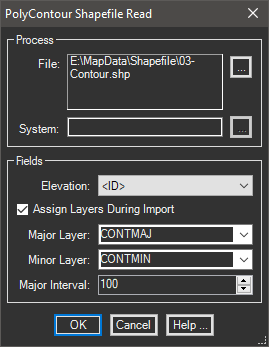
Since the intention is saving time, why not place the resulting polylines in the proper layers automatically at the same time. By specifying the numeric interval to use, the tool separates them during import.
This tool is available in: