The list of file formats that CAD users need to deal with never seems to stop growing. For a long time the ESRI Shapefile was pretty much the exclusive format from ESRI users but it was always an export from the GIS. Now users find themselves receiving folders of content with the folder having a .GDB (GeoDatabase) extension.
Now CAD users can easily read the contents of those folders directly into CAD geometry, and export geometry to the same format just as easy.
Import: Importing is as simple as selecting a folder on your computer. Once the folder is selected, the dialog will be populated with the tables contained. The layer (table) name is listed along with the type of objects to be imported, along with coordinate system info.
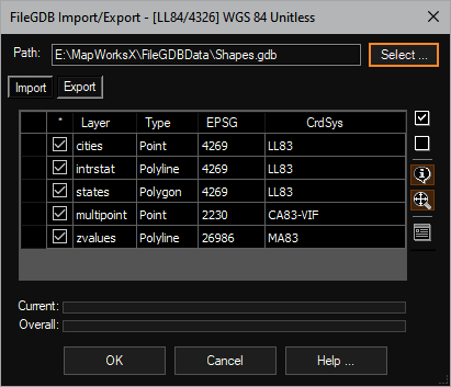
By default all tables are toggled on and you are ready to choose the [OK] button. As entities are created the database table attributes for each record are imported as well. This data (in the form of extended data) is attached to each entity (even polylines). If your current drawing is assigned a coordinate system (likely) the entities are projected to the drawings coordinate system, ready to use in your project.
Export: The process of exporting is just as easy. Simply select your target (new) folder and click the [Select] button to choose the objects in the CAD editor.
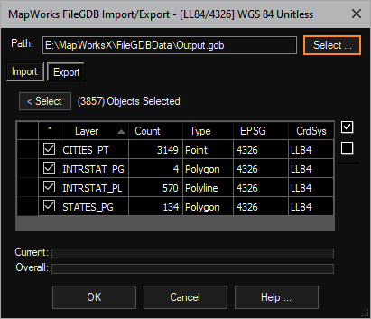
Click the [OK] button and in a few seconds your FileGDB folder is ready to be zipped up and sent to the GIS user. All extended data assigned to the entities are exported as database table record columns so data survives the round trip.
AeccObjects: When using this tool inside our C3DTools, many of the AECC objects are exported as polyline or polygon objects.
This tool is available in: