In mapping environments, the problem occurs when you receive a drawing that has not been properly assigned a coordinate system. Without a proper system assigned it’s nearly impossible to merge data from other systems or view the project in tools like Google Earth. A glance at the coordinates indicate large numbers that should reflect a known system, not random coordinates.
The first logical thing (in code) is to search through the defined systems and evaluate whether the usable coordinate window encloses a designated point, such as the center of the drawings extents or a picked point.
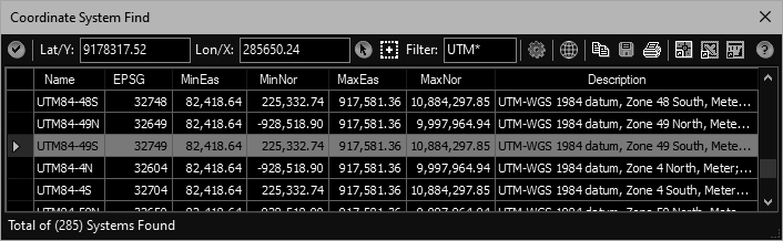
However, that can still lead to hundreds of systems to sort through, even if you can limit the list with a filter mask. We found a proper way to find the needle in the haystack so to speak.
After results grid is populated, this tool can create a KML file (opened in Google Earth) containing labeled place marks of the coordinate in all the resulting systems. This allows the user to simply zoom/pan to the known location on the planet and the appropriate system will have a place mark at the sites location.
From there it’s simply a matter of returning to CAD and selecting that row in the list and clicking the (✔) button to assign the system.
This tool is available in: