When gravity and moisture begins to work on steep slopes (disturbed or natural) the results are often less than optimal and slides occur. This can present the need to install anchor bolts and plates going from the loose surface to a more stable rock strata underneath. Boreholes can help determine the location of the stable strata, but from the surface it’s not readily apparent how far (on a given slope) you will need to drill to reach the stable member.
That problem brought about what we call grade vectors. Using two defined TIN surfaces and having known starting points and desired slopes, it was just a matter of projecting a vector to intersect the target surface. In this simple example there are only five shown, but on real projects there would be hundreds. This meant that random pick and point was not going to be practical, so we decided to use source pointer blocks that defined the beginning point and had attributes both for source and derived information.
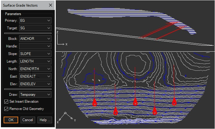
Collecting all the source information like the two surfaces, block name and slope, we provided for the user to push derived information back into the blocks (to be harvested with a tool like EATTEXT for report generation), along with generating visual checking geometry such as the 3D lines from the block insert to the intersection points. To eliminate as much work as possible we also set the elevation of the insert to it’s proper value on the primary surface.
The graphic results are shown below. In the event the user decides to add or modify any of the starting points, the routine will automatically remove the old vectors and regenerate the new ones (on the same layer as the source block).
Once the source content is prepared, it only take s few seconds to generate hundreds of projections, saving the engineer time and the client money.
This tool is available in: