When you receive a drawing containing survey points from outside sources, many times they are not ready for use in your system. They are many times simple blocks with varying attributes (if you’re lucky) but almost always require some reworking. While there are times when you can use CAD block export to create a CSV file for import, your results will vary and it usually requires jumping through hoops.
Since we don’t believe in behaving like well trained circus animals, our goal was to produce a tool to convert the blocks (no matter how diverse) to system points in place in one step (while cleaning up the old geometry).
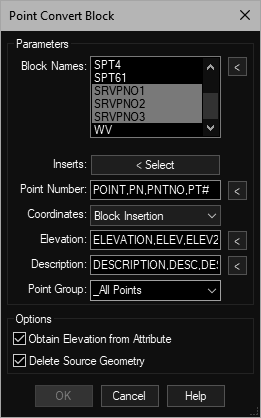
Beginning with the versatility to select multiple block names (it can happen), then simply selecting the inserts and providing a few other parameters (like picking one attribute to show the point number tag). Sometimes you want to acquire the elevation from the insert, sometimes you need to use one of the blocks attributes. Then there is the results of Civil3D’s Export to AutoCAD tool which creates anonymous blocks containing mtext objects (no attributes).
In a couple of seconds (depending on the number of points) you have a collection of system points ready to use. We handle every combination seen so far and if necessary we’ll revise to handle yours if we can’t already.
This tool is available in: